
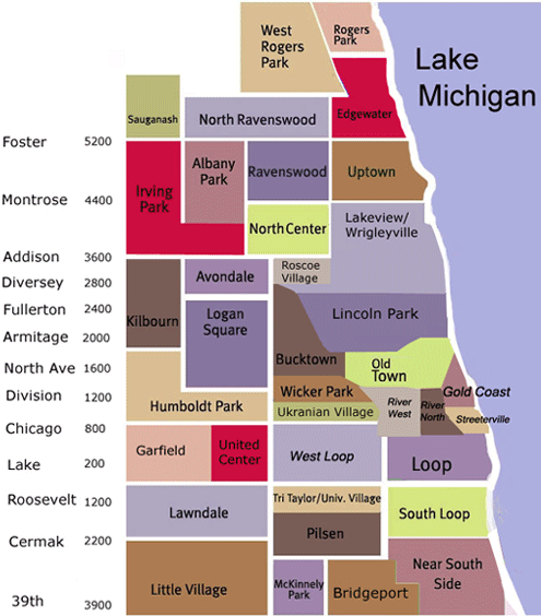
Chicago Neighborhoods
Each neighborhood in Chicago has its own unique spin on the city lifestyle. Scroll down to learn about each neighborhood to find the right fit fo you.
Explore the neighborhoods via the CONDOChicago YouTube!
The Loop
The Loop is what locals call the historical center of downtown Chicago. It is the second-largest central business district in the United States, after Midtown Manhattan. Bounded on the west and north by the Chicago River, on the east by Lake Michigan, and on the south by Roosevelt Road, the value of its real-estate shaped an architectural style dominated by high-rises. Notable buildings include the Home Insurance Building, considered the first skyscraper; the Chicago Board of Trade Building, a National Historic Landmark; and the Sears Tower, the tallest in the United States. Some of the historic buildings in this district were instrumental in the development of high-rises. Chicago's rational street numbering system originates in the Loop at the intersection of State Street and Madison Street.
The term "The Loop" has different meanings. The boundaries as designated by the City of Chicago are the Chicago River to the north and west, Roosevelt Road to the south, and Lake Michigan to the east, though the original boundary is strictly the area circled by the elevated CTA tracks. As the downtown area and its many high-rises expanded out past the community area over the years, "The Loop" has been used more generally to denote the entire downtown as opposed to just the community area. The term even more specifically applies to the section of the community area surrounded by the circuit formed by Chicago's 'L' trains. The circuit runs along Lake Street on the north, Wabash Avenue on the east, Van Buren Street on the south, and Wells Street on the west. The name, however, predates the elevated loop, coming from a streetcar loop in 1882.
This area has a wealth of shopping opportunities, including the Loop Retail Historic District, although it competes with the more upscale Magnificent Mile area to the north.
Lincoln Park
Named after Lincoln Park, a vast stretch of park belonging to the Chicago Park District, the community area is anchored by the Lincoln Park Zoo and DePaul University. Although boundaries are not precisely defined, the Lincoln Park neighborhood is generally considered to be bordered on the north by Diversey Parkway, on the west by Clybourn Avenue, on the south by North Avenue, and on the east by the public park of the same name.
There are many boutiques, movie theaters, retail stores, restaurants and coffee shops. There are also many bars and clubs in the area, especially along Lincoln Avenue between Diversey and Armitage. In 2007, Forbes Magazine named the area between Armitage St, Willow St, Burling St, and Orchard St as the most expensive block in Chicago.
Lake View
Lakeview, especially within the Lake Shore Drive and Broadway Avenue corridors, consists of upscale condominiums and comparably higher-rent midrise apartments and lofts. Small businesses, boutiques, restaurants and community institutions are found along Broadway Avenue and North Halsted Street.
Formerly a working class neighborhood, Wrigleyville is the neighborhood directly surrounding Wrigley Field along North Clark and West Addison Streets. Actual boundaries are undefined, with some sources citing Wrigleyville as spilling into adjacent enclaves like Lake View East and Northalsted. Wrigleyville features low-rise brick buildings and houses, some with rooftop bleachers colloquially called Wrigley Rooftops where people can purchase seats to watch baseball games without having to pay Major League Baseball ticket prices. Proprietors are able to do so under special agreements with the Chicago Cubs organization.
Bucktown / Wicker Park
Bucktown is a neighborhood filled with character and art. It lies just to the north of Wicker Park, between North and Fullerton avenues, and from the Kennedy Expressway (routes 90/94) west to Western.
Once a neighborhood comprised of mostly Polish immigrants, Bucktown gets its name from the goats (called bucks) kept in the backyards of its early residents. The area's rejuvenation was started by local artists, once attracted by cheap rents and accessibility to the Loop and expressways.
The central art district is bordered by Milwaukee, Damen, Wabansia and North avenues. There many galleries in and above store fronts and the historic Flat Iron Building houses galleries of many established and up-an-coming artists. This area is also the location of the annual Bucktown Arts Fest, every August, and the Around the Coyote art festival in September.
Just about every corner hosts one of many neighborhood taverns. North and Damen avenues boast smoky late-night music clubs such as the famous Double-Door, and cosmopolitan clubs, boutiques, and restaurants. Bucktown also contains several remarkable churches, the legacy of early Polish immigrants.
After many years of gentrification, the architecture is made up of once-humble cottages decked with skylights, converted lofts, new condos, brownstones, two- and three- flats, and the occasional elegant mansion.
Wicker Park is a Chicago neighborhood northwest of the Loop, south of Bucktown. Charles and Joel Wicker purchased 80 acres (324,000 m²) of land along Milwaukee Avenue in 1870 and laid out a subdivision with a mix of lot sizes surrounding a four-acre (16,000 m²) park. The Great Chicago Fire of 1871 spurred the first wave of development, as homeless Chicagoans looked to build new houses. Wicker Park proved especially popular with German and Swedish merchants, who built large mansions along the neighborhood's choicest streets--particularly on Hoyne and Pierce, just southwest of North & Damen, known then as Robey.
After World War II, Wicker Park became more ethnically diverse with an influx of Puerto Rican immigrants. Urban renewal projects were undertaken to combat "urban blight" in some parts of the neighborhood, but disinvestment continued at a rapid clip. Chicago and Wicker Park reached a nadir in the 1970s, a decade when the city overall lost 11% of its population; during the 1970s, hundreds of insurance arsons were reported in Wicker Park, and many small factories in the area (many in woodworking) closed or moved away.
Efforts by community development groups to stabilize the community through new affordable-housing construction in the 1980s coincided with the arrival of artists attracted by the neighborhood's easy access to the Loop, cheap loft space in the abandoned factories, and distinctly urban feel.
Today, the neighborhood is best known for its numerous commercial and entertainment establishments and being a convenient place to live for downtown workers due to its proximity to public transportation and the loop. Many new homes have been built as well as older homes being restored. This has led to increased business activity, with many new bars, restaurants, and stores opening to serve these individuals. Much of Wicker Park was designated as a Chicago Landmark District in 1991.
Logan Square
Logan Square proves that it is hip to be square after all. The Northwest Side neighborhood, named one of the coolest in the country, attracts residents with its artistic bohemian vibe, park-like boulevards, and thriving dining scene.
The Logan Square Boulevards District, lined with beautiful homes and mature trees, is a designated Chicago landmark.
Although it’s surrounded by some of Chicago’s trendiest areas for nightlife, the neighborhood definitely holds its own. Logan Square is home to locally-owned restaurants, bars, and bistros, including hotspots noted by Bon Appétit as among Chicago’s best. Artists and musicians live and work in the neighborhood, performing and displaying their art at local coffee shops, cafes, and theaters.
Known for its historic greystones, large bungalows, and stately mansions, Logan Square is undergoing a boom of residential development, including condominiums, lofts, townhomes, three-flats, and single-family homes at a variety of price points. While there is ample new construction, the community still retains its historic charm by repurposing and preserving its landmarks.
The neighborhood’s easy access to the CTA Blue Line is another draw for residents along with The 606 trail.
The Near North
Near North neighborhoods consist of River North, Streeterville, Gold Coast and Old Town.
The River North Gallery District in Chicago is in the Near North Side, Chicago. It hosts the largest concentration of art galleries in the United States outside of Manhattan. Though, like most city neighborhoods, the exact boundaries are debatable a common definition puts the District in the area north of the Merchandise Mart, south of Chicago Avenue, east of Orleans and west of Lasalle. As it has grown, and the area has gentrified, galleries can also now be found west of Orleans and east of Lasalle, though the core area still contains the highest concentration of galleries. Along with hundreds of art galleries, the area holds many bars, dance clubs, popular restaurants, and entertainment venues.
Streeterville is a neighborhood in Chicago north of the Chicago River. It is bounded by the river on the south, Michigan Avenue on the west, and Lake Michigan on the north and east. Legend says the reclaimed land on which the neighborhood is built owes its existence, solely, to George Streeter. In the late 1880s, George 'Cap' Streeter claimed his boat hit a sandbar just off the shoreline during a storm and there it stayed; he and his wife made this their new home. The Streeters encouraged dumping in this area and, after several years, the debris built up and became solid land. George claimed this 'new land' as an independent territory in respect to an 1821 government survey that declared Chicago, and Illinois, property lines terminated at the shoreline. Under his homesteading rights as a Civil War Veteran, he declared the new land to be the District of Lake Michigan. Naturally, the powers that be eventually got around to seizing this land by force, and it is now home to some of the most expensive real estate in Chicago.
Streeterville houses some of Chicago's tallest skyscrapers and most upscale stores, hotels, restaurants and theaters, as well as Northwestern University's Feinberg School of Medicine, School of Continuing Studies, and School of Law. The Magnificent Mile portion of Michigan Avenue is part of Streeterville, as is the number one tourist attraction in Chicago, Navy Pier.
The Gold Coast is the wealthiest neighborhood in Chicago and the second wealthiest neighborhood in the United States. Only Manhattan's Upper East Side is more affluent. The Gold Coast consists mostly of high-rise apartment buildings on Lake Shore Drive, facing Lake Michigan, but also includes low-rise residential blocks inland. As with many neighborhoods, its exact borders are subject to dispute, but generally extend south to Oak west to LaSalle.
The Gold Coast was an unexceptional neighborhood until 1885, when Potter Palmer, former dry goods merchant and owner of the Palmer House hotel, built a fanciful castle on Lake Shore Drive. Over the next few decades, Chicago's elite gradually migrated from Prairie Avenue to their new homes north of the Loop. The "Gold Coast Historic District" was listed on the National Register of Historic Places on January 30, 1978.
Old Town (sometimes called Old Town Triangle) is bounded by Armitage Avenue on the north, Division Street on the south, Larrabee Street on the west, and Clark Street on the east. It sits inside the community areas of Lincoln Park and the Near North Side, and is part of Chicago's 43rd ward.
The heart of Old Town is Wells Street which hosts an art fair each summer at the same as the Old Town Art Fair. Wells has numerous condo residences, restaurants and boutiques and is famous for Second City and Zanies comedy.
Roscoe Village / North Center
Roscoe Village refers to a neighborhood on the North Side of Chicago. While not part of any official city map, Chicago residents perceive the boundaries of the neighborhood to be Addison Street, Belmont Avenue, Western Avenue, and Ravenswood Avenue. The primary feature of Roscoe Village is Roscoe Street, which bisects the neighborhood's boundaries between Addison Street and Belmont Avenue. Roscoe Street is populated by businesses and residents. People have been living in Roscoe Village since the 18th Century, when the area was inhabited by the Fox Indians. Today the area is home to over 6,200 residents.
North Center refers to the neighborhood bordered by Addison on the south, Montrose on the north, the Chicago River on the west and Ashland (from Addison to Irving Park) and Clark (Irving Park to Montrose) on the east. The “heart of Chicago’s north side" has grown since the 1870s when the area was only accessible by the Chicago River and Little Fort Road (now known as Lincoln Avenue). Northcenter is considered a vibrant neighborhood with an eclectic mix of retailers, restaurants, live music, live theater, and service-oriented businesses. Northcenter’s history is deeply rooted in European cultural influences, and that history can be seen in the architectural charm of the homes and buildings from the late 1800s and early 1900s.
The neighborhood continues to grow and become more culturally diverse. The neighborhood includes bowling alleys, three city parks, a nearby library, a nearby movie theater complex, and Town Square. The Northcenter Chamber of Commerce also hosts free family and community events throughout the year. Many believe Northcenter’s greatest appeal to be its small-town atmosphere, which it preserves while still nested in the middle of a world-class city. This also may explain why so many families have remained in Northcenter for multiple generations. Perhaps this is also why Northcenter is frequently referred to as one of “Chicago’s best-kept secrets.”
West Loop
The West Loop makes up the north central area of the Near West Side, west of Chicago's Loop. It is bordered by the Kennedy Expressway to the east, Grand Avenue on the north, the Eisenhower Expressway to the south, and Ashland to the west. The neighborhood also extends to the Chicago River south of Madison St. This area is called the West Loop Gate. Comparable to New York City's Meatpacking District, the West Loop is a former manufacturing corridor turned art-edgy neighborhood. The West Loop is made up primarily of warehouses that are still in use or recently converted to loft condominiums, newly constructed "loftominiums," restaurants, night clubs, a growing number of art galleries, and some retail.
South Loop
Most of the area south of Congress Parkway and east of the Chicago River, possibly excepting Printer's Row, is referred to as the South Loop. The southern boundary of the neighborhood is under debate. While the southern boundary for the community area is Roosevelt Road, the term "South Loop" is often used to describe an area that extends as far south as 18th Street or Cermak Road. Numerous shops south of Roosevelt Road with "South Loop" in their name hint that this more generous definition may be gaining recognition.
The more restrictively-defined area includes River City, the northern half of Dearborn Park, and portions of State Street, Wabash Avenue, and Michigan Avenue. The more generous definitions would include the Central Station development, Dearborn Park II, the Prairie District, and even the northern growth of Chinatown.
The major landowner in the South Loop is Columbia College Chicago, a private school that owns 17 buildings. Also to be found here is the National Vietnam Veterans Art Museum, championed by Mayor Daley.
Lincoln Square
Lincoln Square exudes both trendiness and old-world charm.
The community has a number of ever-popular restaurants and bars, and Lincoln Avenue offers an eclectic mix of sophisticated eateries, corner cafes and favorite neighborhood hangouts.
Centered around a bustling shopping and dining district on Chicago's North Side, Lincoln Square became one of Chicago's first commuter suburbs when the Ravenswood elevated train line was completed in 1907. Today residents have convenient access to the CTA Brown Line and Metra’s Union Pacific North Line.
The neighborhood’s quiet residential streets are lined with bungalows, greystones and brick two- and three-flats. Lovely Victorian and Prairie School homes can be found along the North Branch of the Chicago River. New-construction options are also available in Lincoln Square and include single-family homes, townhomes, three-flat condominiums and mid-rise buildings.
Lincoln Square’s lively cultural scene includes the Old Town School of Folk Music as well as annual festivals such as the Square Roots festival and the German-American Fest, which draws crowds from all over the Midwest.